Hydrologic / Hydraulic Analysis and Gate / Pump Optimization Study for Clear Creek Watershed
Share Hydrologic / Hydraulic Analysis and Gate / Pump Optimization Study for Clear Creek Watershed on Facebook
Share Hydrologic / Hydraulic Analysis and Gate / Pump Optimization Study for Clear Creek Watershed on Twitter
Share Hydrologic / Hydraulic Analysis and Gate / Pump Optimization Study for Clear Creek Watershed on Linkedin
Email Hydrologic / Hydraulic Analysis and Gate / Pump Optimization Study for Clear Creek Watershed link
STATEMENT OF WORK
Proposed Tasks:
1. Review the Coastal Texas Protection and Restoration (Coastal TX) Study by USACE and TX-GLO for Clear Creek watershed
2. Baseline hydrodynamic model setup and scenario analysis
3. Pump station and gate scenario analysis and optimization
Study
Objective
Investigate the flood impacts of the proposed gate and pump station on Lower Clear Creek watershed and evaluate potential configuration options for further flood mitigation
-
Task 1
Share Task 1 on Facebook Share Task 1 on Twitter Share Task 1 on Linkedin Email Task 1 link
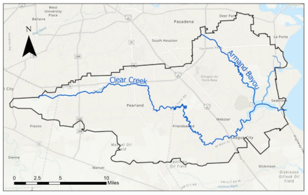
TASK 1: REVIEW COASTAL TX STUDY
Focus on the Clear Lake gate and pump system
- 75-ft floating sector gate for boat traffic
- Circulation gates for water quality and tidal flow exchange
- Pump station with 20,000 cfs capacity
- 17-ft floodwall

-
Task 2
Share Task 2 on Facebook Share Task 2 on Twitter Share Task 2 on Linkedin Email Task 2 link
TASK 2: BASELINE HYDRODYNAMIC MODEL
 Baseline model setup
- HEC-RAS 2D model of Lower Clear Creek and Armand Bayou watersheds
- HCFCD Map and Model Management (M3) models used as reference
- Baseline model validated / calibrated against recent historical storms (e.g., Harvey 2017, Beryl 2024)
Baseline scenario analysis

- Surge-only scenarios: 100-yr, 500-yr storm surge
- Precipitation-only scenarios: 10-yr, 25-yr, 100-yr, 500-yr rainfall
- Compound scenarios: select combinations of a and b
-
Task 3
Share Task 3 on Facebook Share Task 3 on Twitter Share Task 3 on Linkedin Email Task 3 link
TASK 3: GATE AND PUMP STATION OPTIMIZATION
Based on findings from Task 2, select gate and pump station configurations will be evaluated.
- Performance metrics: floodplain extent, number of structures / residential properties flooded, flood depth at critical facilities / watch points
- Operation of pumps and gates during a storm (e.g., Harvey 2017)
- Optimize number of pumps and their capacities for targeted flood reduction


Page last updated: 26 Aug 2025, 12:34 PM